Liaoning
Liaoning ▶ (Simplified Chinese: ÁÉÄþ; Traditional Chinese: ß|ŒŽ; pinyin: Li¨¢on¨ªng) is a province of the People's Republic of China located in the northeastern part of the country. Liaoning borders the Yellow Sea (Korea Bay) and the Bohai Gulf in the south, North Korea to the southeast, Jilin to the northeast, Hebei to the west, and Inner Mongolia to the northwest. The Yalu River marks the border between North Korea and the Chinese provinces of Jilin and Liaoning. It empties into the Korea Bay between the cities of Dandong in Liaoning and Sinŭiju in North Korea.
"Li¨¢o," an ancient name for this region, had been adopted by the Liao Dynasty (Khitan Empire) founded by Abaoji, that ruled the area between 907 and 1125 C.E.. "N¨ªng" means "peacefulness." The modern province was established in 1907 as Fengtian province (·îÌì pinyin: F¨¨ngti¨¡n; Postal map spelling: Fengtien) and the name was changed to Liaoning in 1929. Under the Japanese puppet Manchukuo regime, the province reverted to its old name, but the name Liaoning was restored in 1945 after the Japanese defeat and at the onset of the Chinese Civil War. The province's one-character abbreviation is Liao (ÁÉ pinyin: li¨¢o).
The province was significant in the founding of Korea and during the first 3000 years of Korea's history. Liaoning, far from the centers of power in China, represented a wilderness that could hide renegade tribes that wanted to overthrow the current Chinese dynasty and also served as a region to create a new kingdom beyond interference from China. Some scholars speculate that Korea could have originated from Chinese immigrants unhappy with the dynasty's rule who sought to create their own kingdom on the Korean peninsula. Dangun (2333 B.C.E.) and Gija (1222 B.C.E.) could have been Chinese officials who traveled to the area of present-day Liaoning to establish their own kingdoms. The kingdoms of Gojoseon and Goguryeo followed from them, playing a key role in shaping Korean civilization.
Geography
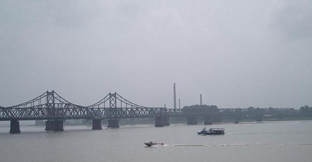
Yalu river bridge between North Korea and Liaoning
Liaoning can be roughly divided into three main geographical regions, with highlands in the west, plains in the middle, and hills in the east. The highlands in the west are dominated by the Nulu'erhu Mountains, which roughly follow the border between Liaoning and Inner Mongolia. This entire region is dominated by low lying hills. The central plains of Liaoning consists of the watersheds of rivers such as the Liao, the Daliao, and their various tributaries. This region is mostly flat and lies at low altitudes, with abundant water and fertile soil, making it the main farming area and commodity grain base in Liaoning. The eastern part of Liaoning is dominated by the Changbai Shan and Qian Shan ranges, which extend into the sea to form the Liaodong Peninsula. The highest point in Liaoning, Mount Huabozi (1,336 m.), is found in this region.
Liaoning has a continental monsoon climate, and rainfall averages to about 440 to 1130 mm annually. Summer is usually rainy while the other seasons are mostly dry.
Major cities:
Aerial view of Dalian, China
- Shenyang
- Dalian
- Anshan
- Liaoyang
- Fushun
- Dandong
- Jinzhou
- Yingkou
Administrative divisions
Friendship Square in Dalian
Liaoning is composed of fourteen prefecture-level cities:
- Shenyang (ÉòÑôÊÐ : Sh¨§ny¨¢ng sh¨¬)
- Dalian (´óÁ¬ÊÐ : D¨¤li¨¢n sh¨¬)
- Anshan (°°É½ÊÐ : Ānsh¨¡n sh¨¬)
- Fushun (¸§Ë³ÊÐ : F¨³sh¨´n sh¨¬)
- Benxi (±¾ÏªÊÐ : B¨§nx¨© sh¨¬)
- Dandong (µ¤¶«ÊÐ : D¨¡nd¨ng sh¨¬)
- Jinzhou (½õÖÝÊÐ : J¨«nzh¨u sh¨¬)
- Huludao (ºù«µºÊÐ : H¨²lud¨£o sh¨¬)
- Yingkou (Óª¿ÚÊÐ : Y¨ªngk¨¯u sh¨¬)
- Panjin (Å̽õÊÐ : P¨¢nj¨«n sh¨¬)
- Fuxin (¸·ÐÂÊÐ : F¨´x¨©n sh¨¬)
- Liaoyang (ÁÉÑôÊÐ : Li¨¢oy¨¢ng sh¨¬)
- Tieling (ÌúÁëÊÐ : Ti¨§l¨«ng sh¨¬)
- Chaoyang (³¯ÑôÊÐ : Ch¨¢oy¨¢ng sh¨¬)
These prefecture-level cities are in turn divided into 100 county-level divisions (17 county-level cities, 19 counties, eight autonomous counties, and 56 districts), which are then further subdivided into 1511 township-level divisions (613 towns, 301 townships, 77 ethnic townships, and 520 subdistricts).
Economy
Construction in Dalian harbor
Liaoning has the largest economy in northeastern China. Its nominal GDP for 2006 was 925.7 billion yuan (US$117.2 billion), making it the 8th largest in the country. Its per capita GDP was 21,802 yuan (US$2,760).
Some of the province's main agricultural products include maize, sorghum, cotton, and soybeans. In addition, the region around Dalian produces three-quarters of China's exported apples and peaches. Liaoning's other fruits include pears from Beizhen of Jinzhou, white pears from Huludao and Suizhong, and apricots and plums from Gushan of Dandong.
Liaoning as a whole has plentiful fishing resources with its marine life area ranking second in China. The sea off the coast of Dalian abounds with quality seafood, including abalones, sea cucumbers, scallops, prawns, crabs, and sea urchins. The big fish of Dandong, the jellyfish of Yingkou, and the clams of Panjin are known worldwide for their good taste right from the sea and in a variety of products made in Liaoning for export domestically and internationally. In addition, large quantities of salt are produced along the coast.
Liaoning has the most iron, magnesite, diamond, and boron deposits among all of the provinces of China. This mineral resource base has contributed strongly to Liaoning's position as one of China's most important industrial bases, covering a wide range of industries, such as machinery, electronics, metal refining, chemical industries, construction materials, coal, and others. Along with these industries, Liaoning is also an important source of petroleum and natural gas, with the Liaohe Oil Field serving as the third largest oil and natural gas field in all of China. Its reserves account for 15 percent of the country's total oil and 10 percent of the country's total natural gas.
The cities of Dalian and Yingkou both have been developed as major ports and economic gateways for all of northeast China.
Five Points, One Line
The Party Secretary of the Liaoning Provincial Committee of the Communist Party of China, Li Keqiang, initiated the development of a strategy entitled ¡°Five Points, One Line,¡± which he first proposed on a visit to Yingkou in late 2005. Liaoning formally launched the development strategy for the entire Liaoning coastline in early 2006, so as to re-invigorate the provincial economy from its traditional status as the ¡°rustbelt¡± of Chinese state-owned enterprises.
The "Five Points" indicate five key development areas in the province and cover seven zones: the Changxing Island Harbor Industrial Zone in Dalian, the Yingkou Coastal Industrial Base, the Liaoxi Jinzhou Bay Coastal Economic Zone, Dandong, and the Zhuanghe Huayuankou Industrial Zone. The five zones together cover a planned area of nearly 500 square kilometres.
The "One Line" aspect of the strategy represents a new motorway along the coast which will connect all of these various developing economic areas. The coastline of 1,433 kilometers will become the main connection between the five zones, through which 6 provincial cities, 21 counties, and 113 towns will be interlinked. The new coastal motorway will directly connect the entire rim of five zones around the Bohai Sea, and will be completed by 2009.